Mapping & Inspection
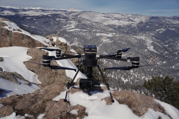
The world of aerial data collection is evolving rapidly, and professionals across industries are seeking reliable, high-performance solutions to enhance efficiency and accuracy. WISPR Systems’ SkyScout stands out as a versatile, rugged and highly capable drone designed for photogrammetry, LiDAR, mapping, surveying and inspection applications. Whether you’re capturing high-resolution images for 3D modeling, conducting detailed land surveys or inspecting critical infrastructure, SkyScout is built to deliver unmatched precision and performance.
- Photogrammetry: Precision Image Capture for 3D Modeling
Photogrammetry is the backbone of many mapping and modeling applications, requiring drones that can capture high-resolution, georeferenced images with exceptional clarity. SkyScout is equipped with:
- Multiple camera options with mechanical shutters for distortion-free imagery
- High-precision GPS to ensure accurate geotagging
- Long flight endurance, enabling extensive area coverage in a single mission
- Automatic Geotagging of pictures to streamline your workflow
With SkyScout, surveyors and engineers can generate detailed 3D models, orthomosaic maps and digital elevation models (DEMs) with ease. Its ability to collect accurate aerial imagery with minimal overlap reduces processing time while improving data quality and resolution.
- LiDAR: Advanced Terrain Mapping with Unparalleled Accuracy
LiDAR (Light Detection and Ranging) has revolutionized topographical mapping, forestry analysis and infrastructure planning. SkyScout is engineered to seamlessly integrate with LiDAR sensors, allowing professionals to:
- Penetrate vegetation and capture bare-earth terrain data
- Generate high-density point clouds with sub-centimeter accuracy
- Perform precise volume calculations for construction and mining
SkyScout’s robust flight stability and payload capacity ensure that LiDAR sensors operate smoothly and efficiently, even in challenging environments. The result? Highly detailed, actionable data for industries that demand the highest level of accuracy.
- Mapping and Surveying: Efficient Data Collection for Large-Scale Projects
Accurate mapping and surveying require drones with long flight times, high payload capacity and advanced navigation systems. SkyScout meets these demands by offering:
- Autonomous flight planning with terrain following
- RTK (Real-Time Kinematic) and PPK (Post Processing Kinematic) positioning for centimeter-level accuracy
- Extended flight durations to cover large areas in a single deployment
From construction site planning and land development to agricultural analysis and environmental monitoring, SkyScout provides professionals with the tools to collect, process and analyze geospatial data more efficiently than ever before.
- Inspection: Safe, High-Resolution Monitoring of Critical Infrastructure
Infrastructure inspections demand close-range, high-detail imaging, often in environments that are difficult or dangerous for human access. SkyScout enhances safety and efficiency by enabling:
- Detailed asset inspections of power lines, wind turbines, bridges and pipelines
- Thermal imaging and multispectral capabilities for defect detection
- Live video streaming for real-time monitoring and analysis
By eliminating the need for manual inspections in hazardous locations, SkyScout minimizes downtime, reduces costs and improves overall safety for industries such as utilities, energy and telecommunications.
Why SkyScout? The WISPR Advantage
SkyScout isn’t just another drone—it’s a high-performance UAV designed to meet the evolving needs of industry professionals. With:
✔ Customizable payload options for specialized applications
✔ Extended flight times to maximize operational efficiency
✔ Rugged, field-tested durability for challenging conditions
✔ Seamless software integration for easy data processing
SkyScout provides an all-in-one solution for photogrammetry, LiDAR, mapping and inspections, ensuring unmatched reliability and precision in the field.
Take Your Drone Operations to the Next Level
Ready to enhance your aerial data collection and analysis? Whether you’re a surveyor, engineer, infrastructure inspector or GIS professional, SkyScout is the ideal tool to streamline workflows, improve accuracy and maximize efficiency.
Questions? Contact our team at [email protected] or 478-315-0812.
